
By Ed Barnhart
From an article in Mundo Maya
![]()
|
As the crew of the Palenque Mapping Project, my team and I enter the forest each day with a feeling of anticipation. 1999 is our second year of a three-year project aiming to create the first complete map of the city's extents. Not since the work of Franz Blom in 1923 has a survey of this scale been attempted.
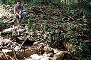
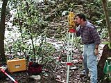
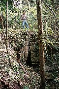
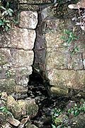
Currently, we are investigating one kilometer to the west of the ceremonial center, an area almost completely undocumented but known to be full of structures. With each day of survey we put together the story of Palenque's outlying population. Hand in hand with the thrill of discovery come the dangers and hardships we face. The terrain is rugged, covered in thick forest up the sides of mountains and valleys. Much of the vegetation is impassible without machete work, literal walls of thick thorn-laden underbrush. The city's ancient name Lakam Ha (meaning Big Water) aptly describes its geographical setting. Many rivers, arroyos and waterfalls make our progress slow, slippery and treacherous. Frequently we find ourselves mapping along the tops of waterfalls, cliffs, and crumbing temple tops. One of our greatest fears is Palenque's abundance of poisonous snakes. Every week we encounter at least one snake, usually over five feet in length. The most commonly encountered is the Nawiaka, whose venom can kill within an hour if not neutralized immediately. Insects, while for the most part harmless, are an annoyance to be overcome. Each member of the crew is covered in an ever-increasing amount of bites. Tick removal is a nightly ritual. Even with all this, we love our work and feel great pride in the maps we create. The mapping crew is small and our methods are simple. First, with a crew of four macheteros leading the way, we reconnaissance sections, generally using waterways as temporary boundaries. As we discover ruined structures we draw them using meter tapes and compasses. Once those initial drawings are made we can plan a route for the survey equipment. Using an electronic transit on a tripod, beams of laser light are bounced off a rod-mounted prism to obtain three-dimensional coordinate points. The rod is placed on every corner, every visible architectural feature, and every geographical point of interest. When all possible points from a given transit station have been shot, the machine is moved farther out and the process is repeated. Meter by meter a data set of thousands of 3D points is acquired. Finally, back in the field office, the data is entered into survey and architectural design software to create the maps. The accuracy, thus far kept under 20cm of error, is checked once in the field by circling the equipment back to known points and then double-checked by computer. Before the Palenque Mapping Project's inception in February of 1998 a total of 541 structures were known to exist at Palenque. As of June 1999 we have identified over 750. Based on our current progress we expect to map over 1500 structures by the project's completion in August of 2000. While many of those structures will not be the large temples we find in Classic Maya ceremonial centers their collective character is revealing something every bit as important, the nature of Palenque's supporting population. Residential neighborhoods, criss-crossed by drains, canals, and aqueducts cover the hills to the east and west of Palenque's central palace for over a kilometer in each direction. By the project's end we will see Palenque not just as a city dominated by powerful elite and priestly classes but as a complete urban center. In addition to contributing to our knowledge of Palenque's ancient past, the Palenque Mapping Project is an excellent example of cooperation between Mexico and the international community. Permission to implement the project comes from an agreement between the Mexican Government's archaeology department (INAH) and the Pre-Columbian Art Research Institute (PARI). Project support comes primarily from the Foundation for the Advancement Mesoamerican Studies, Inc. (FAMSI), a US based foundation recently formed to provide support for ongoing anthropological research in Mexico and Central America. Topcon, a Japanese based provider of survey products, supports the project through the loan of state of the art field equipment. Thus, through the support and cooperation of many parties, my crew and I continue to push our way through the forest, emerging each day with another new piece of the ancient and beautiful puzzle that is Palenque.
|
| 
|